Contrails
What is the Contrails?
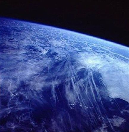
The contrail is not naturally occurring. These clouds are cirrus like markings spread across the sky by aircraft flying at 16,500 feet (5 kilometer) or higher. "Contrails"is an abbreviation for "condensation trails."
A contrail is the frozen trail of water droplets emitted by an aircraft's exhaust. At high levels of the troposphere, or low levels of the stratosphere where large aircraft travel, the air temperature is typically below -68°F (-56°C ). At this temperature, water droplets freeze within seconds, appearing white against the blue sky.
When the surrounding air is relatively dry, these artificial clouds are thin, dissipate quickly, and are generally not visible from the ground.
Contrails formed in air with a high relative humidity, however, are thicker than their dry- air counterparts. They may remain visible in the sky for a half hour or more, particularly if wind are light. During this time, they may spread apart, forming a sheetlike cloud.
A thick, persistent contrail is a sign of moisture in the upper air. This sign is often the first clue that a frontal system, a weather pattern that accompanies an advancing front, is approaching.
© NASA
