Cumulonimbus
What is Cumulonimbus?
While the dark base of a cumulonimbus can form as low as 300 meters above the ground, its top may reach 12 kilometers, which is well into the upper reaches of the troposphere. In the tropics and subtropics, the top of the largest species of thunderstorm clouds, cumulonimbus incus, a fully developed cumulonimbus that reaches the top of the largest species of thunderstorm clouds, cumulonimbus incus, a fully developed cumulonimbus that reaches the top of the troposphere, can surge beyond the troposphere and into the stratosphere, can surge beyond the troposphere and into the stratosphere, the second-layer of the atmosphere.
A cumulonimbus cloud will keep growing taller as long as both convection and atmospheric instability persist the atmosphere is considered unstable when the temperature of the surrounding air drops with increasing altitude, at a faster-than-average rate. On average, air temperature drops 6.5°F per kilometer one ascends.
A cumulonimbus cloud will keep growing taller as long as both convection and atmospheric instability persist the atmosphere is considered unstable when the temperature of the surrounding air drops with increasing altitude, at a faster-than-average rate. On average, air temperature drops 6.5°F per kilometer one ascends.
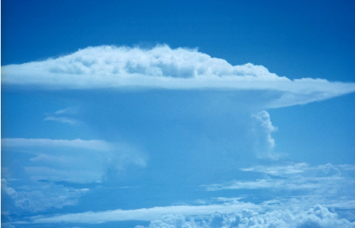
If a cumuluonimbus cloud extends into the stratosphere, it will encounter a reversal in the cooling trend: Temperature in the stratosphere rises with altitude. This change brings a halt to the cloud’s vertical growth. If the updrafts, upward-blowing columns of air, continue within the cloud, it will grow outward. Ice crystals at its top will then be shared off by the jet stream, the fastest upper-air winds, and fan outward into a wedge-shaped mass, forming cumulonimbus incus. This cloud is so –named because its top is similar in appearance to a blacksmith’s anvil, the Latin name for which is Incus. Cumulonimbus incus clouds may appear singly or in ominous-looking rows called squall lines.
Ice that shears off the top of this clouds anvil may form layers of cirrus and cirrostratus clouds that cover an area hundreds of miles down wind. For this reason, cumulonimbus is also referred to as cloud factory.
The lower portions of a cumulonimbus cloud contain liquid water, the middle portions contain both water and ice, and the top is made entirely of ice crystals. Therefore, one cloud can simultaneously produce different forms of precipitation, including rain, snow, and hail, in great quantities.
A cumulonimbus cloud is a giant storehouse of energy. Within it are powerful updrafts and downdrafts of wind, blowing at speeds greater than 88 kph. Thunder, lightning, and tornadoes all may accompany storms produced by cumulonimbus clouds.
