Cumulus
What is Cumulus?
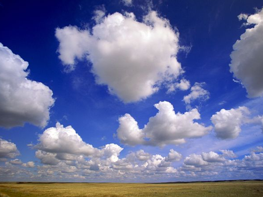
Formed on humid days, they look like white or light-gray cotton puffballs of various shapes set against the blue sky. They are typically about a half-mile wide, and their edges are clearly defined.
Cumulus can be distinguished from stratocumulus because cumulus clouds exist singly while stratocumulus clouds exist in groups or rows. While cumulus clouds have rounded top, stratocumulus clouds have relatively flat tops.
Cumulus clouds are produced by convection, the rising of pockets of warm air. This occurs as the Sun warms the ground and the layer of the air above it. The warm air rises, forming a low pressure area. Surrounding air flows in and is also warmed. This process continues until a convection cell is formed. As the air rises, it expands and cools. If it cools below the dew point, clouds will form. Cumulus clouds usually begin forming in the morning and grow throughout the day. They reach their tallest point at the warmest time of day, which is generally midafternoon. In the evening, they begin to dissipate.
As long as the atmosphere is unstable (the ascending air parcel, a small portion of air with a consistent temperature, is warmer than the ambient air) at the height of the cloud base, the cumulus cloud will continue to develop vertically. The top of a cumulus cloud indicates the limit of rising air. Cumulus clouds typically grow to only moderate heights and are associated with fair weather.
When the air is particularly unstable and strong convection occurs, a cumulus cloud can reach great heights. As it surges upward, it passes through the intermediate stage of cumulus mediocris, a medium-sized cumulus wth a lumpy top, and then may become cumulus congestus, which is shaped like a head of cauliflower. During this stage, cumulus clouds grow wider and often run into one another, forming a line of towering rain clouds. If the vertical growth of a cumulus congestus continues, it will evolve into a cumulonimbus, or thunderstorm cloud
When the air is particularly unstable and strong convection occurs, a cumulus cloud can reach great heights. As it surges upward, it passes through the intermediate stage of cumulus mediocris, a medium-sized cumulus wth a lumpy top, and then may become cumulus congestus, which is shaped like a head of cauliflower. During this stage, cumulus clouds grow wider and often run into one another, forming a line of towering rain clouds. If the vertical growth of a cumulus congestus continues, it will evolve into a cumulonimbus, or thunderstorm cloud
